")
")
")
")
")
")
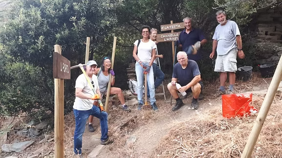
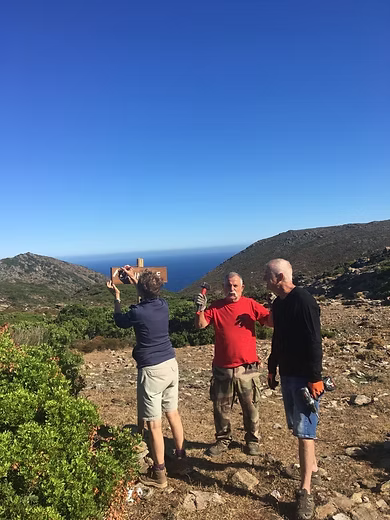
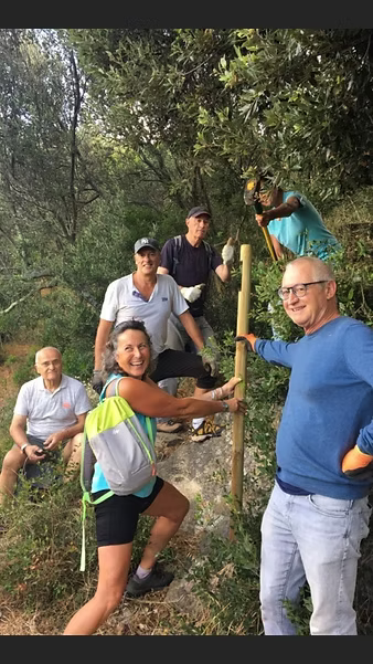
Thanks to the efforts of a team of volunteers and the City Council, four walking trails have been equipped and developed.
Below are the four walking paths chosen for this project:
Many thanks to the volunteers, to Mr. Jacky Lemarc for the trail maps, and to Mr. Jacques Bonnet for the texts.
WALK NO. 1 - THE PORT -
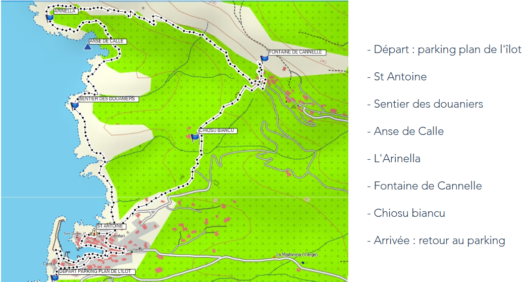
START: from the parking lot located on the island map, head towards the Hôtel de la Jetée, turn left, then immediately right, and go down to the port.
Turn right and walk around the port to the restaurant Le Langoustier.
In front of Le Langoustier, turn right, climb a few steps, and take the alleyway that climbs to the left.
Once you reach a platform, you will see an old washhouse, and when you turn around, you will see a ruined Genoese tower.
Pass to the left of the Saint Antoine chapel, cross the square, and turn left.
About twenty meters further on, you will arrive at the start of the customs officers' path, which you will follow. On the customs path, you'll first come across a renovated fountain called Funtana Vecchjia, then you'll see a ruined boathouse on the seafront.
Further on, on the right, you'll see the Calbelle mill, then you'll cross several small streams (dry in summer).
When you reach Calle Cove, you'll see that its shoreline has been landscaped. 200 meters past Calle Cove, you'll reach Arinella, where there are tamarisk trees.
Leave the customs path by turning right and begin climbing towards Cannelle.
During the climb, you'll see stone walls with cuidoni (stones planted vertically in the walls that were used to create hedges around the plantations to protect them from the wind), and a few meters from the end of the climb, you'll see an old threshing floor. At the top of the hill, turn right and take the path that leads to Cannelle.
To the left of the path, you'll see a cuidoni (small farmhouse), and to the right below the path, you'll see a date palm.
When you reach the first houses below Cannelle, follow the signs to the fountain and retrace your steps to take the path that leads down to the port.
You'll pass Villa Chiosu Biancu and continue along the road for about 100 meters.
Take the path on the right: it will lead you to the port.
Cross the port via the Stretta (a narrow, one-way street) and return to the starting point, passing under the Hôtel du Vieux Moulin and in front of the Hôtel de la Jetée.
APPROXIMATE DISTANCE: 5 KM
APPROXIMATE TIME: 2 HOURS
TRAIL COMMENTS: The red-marked trail is pleasant and not particularly challenging, but caution is still required as some sections are a bit steep and the rocks can be slippery in the rain. You must follow the safety and environmental protection instructions indicated on the sign at the start of the customs officers' trail. The climb to Cannelle is not insurmountable (elevation gain 150 m), but in summer, avoid climbing it during the hottest part of the day. The trails are generally well-maintained.
WALK NO. 2 - THE SHEEPFOLDS -
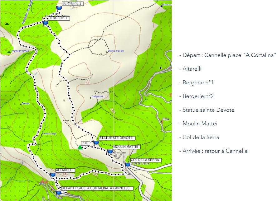
START: from the square in Cortalina to the hamlet of Cannelle
CIRCUIT: From the square in Cortalina, take the small concrete lane that initially becomes a dirt track and will lead you to the last house at the top of the hamlet of Cannelle, at a place called Altarelli. Continue straight towards Grotta alle Piane for about 150 meters and you will reach the Pozpella viewpoint. Continue along the path, crossing the well-shaded undergrowth of Borgone and Bolzaja, where you will see cuidoni (stones planted vertically in the walls that were used to create hedges around the plantations to protect them from the wind). Then you will descend and cross the Tizzioli stream before climbing back up to the Vitelaggio viewpoint. Turn right at the pass and descend towards the first sheepfold of Grotta alle Piane. If you wish, you can go to the second sheepfold: to get there, take the path that passes to the right of the first sheepfold and follow it for about 200 meters and take the same path to return to the first sheepfold. Continue your walk by taking a left-hand uphill path marked with cairns (in addition to the red markings) that you will follow until you reach a dirt track. Turn right onto the track towards the Mattei mill and follow it for about 1 kilometer. About a hundred meters before the Mattei Mill, turn right before the statue of Saint Devota (which you can see from behind) to reach a beautiful viewpoint: pass by a huge pile of stones, descend about thirty meters, and climb up to the small promontory on the left, from where you can admire the magnificent view overlooking the port of Centuri. Then, retrace your steps, pass in front of the statue of Saint Devota, and go to the Mattei Mill. Descend from the Mattei Mill to the Serra Pass via the dirt track (you will find information signs along the way). From the Serra Pass, descend towards Cannelle, first taking the dirt track on your right for about 300 meters, then a path that branches off to your left and will lead you to Altarelli. Reach the square in Cortalina by returning to the dirt track, which eventually becomes a concrete alley.
APPROXIMATE DISTANCE: 7 KM (including the detour to the second sheepfold)
APPROXIMATE DURATION: 3 HOURS
NOTES ON THE ROUTE: The route is marked in red and the trails are of fairly good quality (except for a rockfall on the descent to Cannelle), but the descents can be slippery after rain. It is therefore advisable to wear hiking shoes with non-slip soles. You must follow the safety and environmental protection guidelines, which are outlined on the town hall website. This walk is not recommended in strong winds.
WALK NO. 3 - Hamlet of Orche -
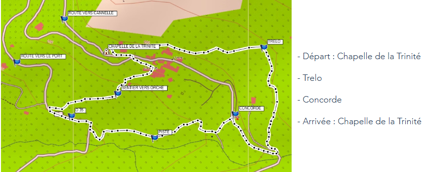
START: At the Chapel of the Trinity in the hamlet of Orche, at the beginning of the Cannelle road.
CIRCUIT: Take the path that climbs to the right behind the Chapel of the Trinity. This path is concreted for about 50 meters and then becomes a dirt track.
Pass above the hamlet of Orche and begin climbing towards the old hamlet of Trelo, where you will see, on your right, the ruined tower of the Mattei family (they were descendants of Sanson Napollon, who was appointed royal governor of the Bastion of France in Algiers by King Louis XIII of France).
After crossing the entire hamlet of Trelo, turn right and descend to the Évilla bridge on the D35.
When you reach the D35, turn right and follow the road for about 170 meters. When you see the La Concorde building on your right, which is the former school of the hamlet of Orche, take the downhill path on your left that will lead you to a platform near a drilling station located to the left of the platform.
Turn right onto the track towards the D35, cross a small stream, and continue downhill on the concrete track on your left towards the D35, passing the small chapel of Santa Maria.
When you reach the D35, turn right and follow the D35 for about 140 meters.
Turn right and take the path that will bring you back to the hamlet of Orche.
At the end of the path, pass under an arch and turn left to reach the D35.
When you reach the D35, turn right, then after about 20 meters, turn left towards Cannelle to return to the starting point.
APPROXIMATE DISTANCE: 2.5 KM
APPROXIMATE TIME: 1 HOUR
NOTES ABOUT THE ROUTE: The route is marked in red, and some parts are quite stony (especially the beginning of the trail to the Pont de l'Evilla bridge). The other paths and trails used are of fairly good quality, but the descents can be slippery after rain. It is therefore strongly recommended to wear hiking shoes with non-slip soles. You must follow the safety and environmental protection guidelines, which are listed on the town hall website.
WALK NO. 4: Camera / Ortinola / Bovalo
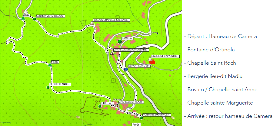
START: At the Chapel of the Trinity in the hamlet of Orche at the beginning of the Cannelle road.
CIRCUIT: Take the path that climbs to the right behind the Chapel of the Trinity. This path is concreted for about 50 meters and then becomes a dirt path.
Pass above the hamlet of Orche and begin climbing towards the old hamlet of Trelo, where you will see, on your right, the ruined tower of the Mattei family (they were the descendants of Sanson Napollon, who was appointed royal governor of the Bastion of France in Algiers by King Louis XIII of France).
!!! I had started, but it's the same text as Circuit No. 3!!!